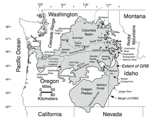
Columbia River Basalt Group
- Vashon glacier begins to melt and recede from Puget Sound region and Columbia Basin around 16,900 years ago (historylink.org)
About 16,900 years ago, the Vashon glacier begins to melt and recede from lands that will come to be known as the Puget Sound region and the Columbia Basin region. By 15,000 years ago, the glacier has retreated to the border of present-day Canada. During its advance, meltwater flowing under the ice sheet had carved out Lake Washington, Lake Tapps, Lake Sammamish, Puget Sound, and Hood Canal. The other major shaper of the land – the pushing of the Juan de Fuca Plate underneath the North American plate, and the docking of terranes (fragments of continents) had already occurred long ago.
- Columbia River drainage basin (Wikipedia)
The Columbia River drainage basin is the drainage basin of the Columbia River in the Pacific Northwest region of North America. It covers 668,000 km2 or 258,000 sq mi. In common usage, the term often refers to a smaller area, generally the portion of the drainage basin that lies within eastern Washington.