Columbia River Basalt Group
- Field Trip Guide to the Geologic Development of the Pasco Basin, South-Central Washington (PDF) (nwgs.org)
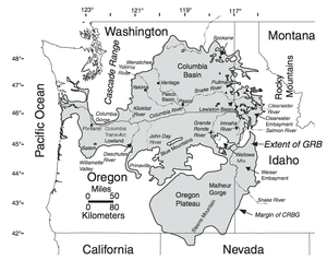
Flood basalt volcanism occurred in the Pacific Northwest, USA, between 17.5 and 6 Ma when over 300 basaltic lavas of the Columbia River Basalt Group (CRBG) were erupted from fissures in eastern Washington, eastern Oregon, and western Idaho (Fig. 1) (Swanson et al., 1979a). These flood basalts cover over 200,000 km2 of the Pacific Northwest and have an estimated volume of more than 234,000 km3 (Camp et al., 2003). Concurrent with these massive basalt eruptions was the folding and faulting of the basalt in the western part of the Columbia Basin and development of generally east-west trending anticlinal ridges and synclinal valleys collectively known as the Yakima Fold Belt
nuclear production complex
- Sutro Baths (Wikipedia)
The Sutro Baths was a large, privately owned public saltwater swimming pool complex in the Lands End area of the Outer Richmond District in western San Francisco, California.
 Columbia River Basalt Group map shows main regions of basalt exposure in Washington, Oregon, Idaho and Nevada, USA. (usgs.gov)
 Columbia River Basalt Group map shows main regions of basalt exposure in Washington, Oregon, Idaho and Nevada, USA. (usgs.gov)