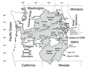
Columbia River Basalt Group
longest river entirely in the state of
- There is no single entry for the entire Yakima river. The first way definition is at https://www.openstreetmap.org/way/319057418 and from there you can query your way downstream until reaching the Columbia River. To query, zoom into a region of the map (such as a river segment) and then right-click and select Query features.
- Yakima River (Wikipedia)
The Yakima River is a tributary of the Columbia River in south central and eastern Washington state, named for the indigenous Yakama people. Lewis and Clark mention in their journals that the Chin-nâm pam (or the Lower Snake River Chamnapam Nation) called the river Tâpe têtt (also rendered Tapteete), possibly from the French tape-tête, meaning “head hit”. The length of the river from headwaters to mouth is 214 miles (344 km), with an average drop of 9.85 feet per mile (1.866 m/km). It is the longest river entirely in Washington state.